Gazdonian Productions: Science Videos for teaching
  • Home
  • "Best of the Web" Videos by Topic
  • Project Based Science
  • Regents Review Earth Science
  • Applied Physics
  • PD & Conferences
  • milkcrate
  • TomGazdaPhotographyandframes
  • hardcopyphoto
  • More...
    • infrared
    • Drone
    • HW Videos
    • Gazda Made Videos
    • Sand Lab
    • Film Your Own Videos
    • Teacher-Made Videos
    • Teaching with YouTube Videos
    • Video Best practices
    • ELL - YouTube Auto-translate
    • Contact
    • About

mapping

earth science review page

Videos note: this page still under construction

Picture
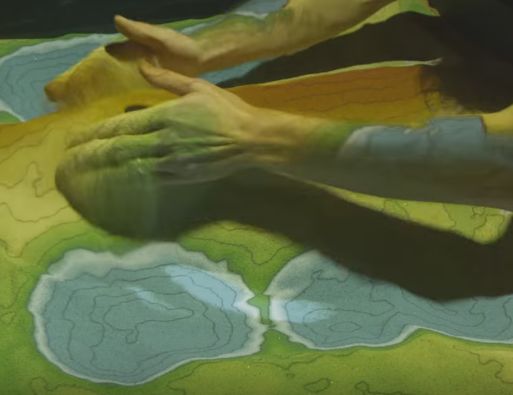
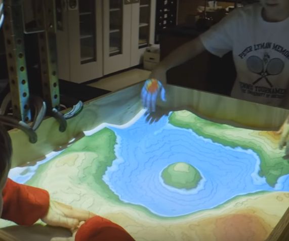
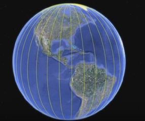
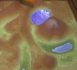
UCLA's Augmented Reality Sandbox [UCLA]:  I only saw this technology for the first time last year and it blew my mind.  Holy cow, this is cool!  My students were equally blown away by this. Another good video of this amazing device/tool/technology. ​
​2 mins ​
This technology was developed at UC Davis.  The website for this project is here:  arsandbox.org
Picture
Augment Reality Sandbox at SUNY Geneseo [Christopher Young]:  Amateur video with distracting conversation but I like it because it shows them really get into using it and exploring what the sandbox can do. Very cool.  
​5 mins
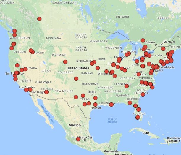
See the "Miscellaneous" section below to find the AR Sandbox near you!
Picture
Intro to USGS Topo Maps [CV Shorey]: By Dr. Christian Shorey from the Colorado School of Mines.
​
3 mins 25 sec
 

Picture
Intro to Contour Lines [CV Shorey]:  Thorough introduction to contour lines from Dr. Christian Shorey from the Colorado School of Mines.
​
7 min 5 sec
 
Picture
Latitude and Longitude [Andy Jensen]:  Basic and to-the-point overview of lat/long.  Clearly presented with good use of visuals.
3 mins 14 sec
Picture
Topo Maps, 1966 US Army Training Film [Jeff Quitney]:
​
Man, I love this kinda stuff.  But even if military training films don't call out to you as much as they do to me, there's a lot of good stuff on topo maps here (starting at 17 mins). My students get a kick out of that mid-60's, no-nonsense US Army style of the video, which is very different from anything they're used to.  I like the idea of using topomaps to find areas for natural concealment shown at the 20:00 mark.
Full video run time: 28 mins


Picture
Find North Without a Compass [AlfieAesthetics]:  You gotta love a science video that begins with "Sup bros!".  Seems very jokey since the guy sounds like Ali G, but it's straight-forward and to-the-point.  And students like it and are engaged while watching, which is half the battle.  I've spring-boarded some quality teaching moments off this video over the years.  It's good to follow this up with some real-life videos of Polaris/Big Dipper.
​1 min 45 sec
Picture
Polaris and star trails [VIMEO - blind summit]:  Filmed in Ditchling Beacon, England this time lapse has a definite trippy vibe.  The lights of passing planes adds a cool element. NOTE:  the room needs to be as dark as possible to show night sky videos.  
​
1 min 23 sec
Picture
Big Dipper/Polaris Time Lapse [Anar Bayarsaikhan]:  Filmed in Mongolia, this video always leads to a class game of "Find Polaris", which students enjoy.
53 secs

Picture
AR Sandbox [okreylos]:  This shows someone slowly "build" a landscape and add water features.  Good to see the features and contour lines clearly.
​
5 min 26 sec
   

The 2nd String On the fringe of the topic.  But still cool.

Picture
42 Amazing Maps [vlogbrothers]: Interesting video to help expand student's idea of what maps really are.  The dude talks about a 1000 miles per hour, but still a really cool above-and-beyond the normal curriculum to show in class.  These guys are big among Global Studies teachers.
3 mins 43 secs

​more to come...


Miscellaneous

Picture
Online Topo Maps [MyTopo.com]:
​
Free access to online topo maps of the US and Canada.  Go to "Onlne maps" the choose "topomaps" on the drop down menu.  
Picture
Current AR Sandboxes in The US:  In case you want to seek one out to get your non-virtual hands on it.  

Lecture notes/map skills

Picture
Basic Topo Map Skills [Michael Sammartano]: Presented very clearly and effectively by a NY teacher.  
11 min 42 sec
Picture
Intro to Topo Maps [Seth Horowitz]:  Clearly presents the basics of topo maps, presented by a NY high school teacher.  
​
15 mins
Picture
How to Draw Topographic Profiles - Computer Version [earthsciencevids]:  Clearly presented.
​
5 min 21 sec

Picture
How to Draw Profiles - Paper and Pencil version [Gazdonian Productions]:  I've been using a similar video in class for years.  I like it because it shows it exactly as the student will actually do it - with their hands and pencil and paper.
4 min 52 sec
Picture
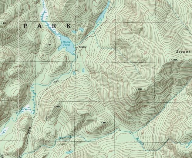
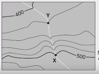
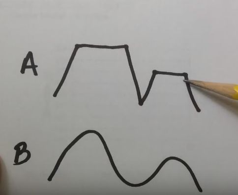
Drawing Isolines #1- Paper and Pencil version [Gazdonian Productions]: Straight forward.
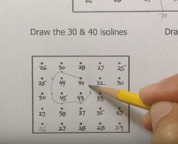
6 min 21 sec
Drawing Isolines #2 has the field values randomly placed, so it's more like a real world field map.  Find it here.
Picture
Find Latitude Using Polaris [Seth Horowitz]:  Good Screencast-style notes for this. NOTE:  it's NY Regents-centric from 4:45 until the end.
​ 6 min 14 sec

Earth Science Review
Contact

About
© COPYRIGHT 2020  ALL RIGHTS RESERVED.
  • Home
  • "Best of the Web" Videos by Topic
  • Project Based Science
  • Regents Review Earth Science
  • Applied Physics
  • PD & Conferences
  • milkcrate
  • TomGazdaPhotographyandframes
  • hardcopyphoto
  • More...
    • infrared
    • Drone
    • HW Videos
    • Gazda Made Videos
    • Sand Lab
    • Film Your Own Videos
    • Teacher-Made Videos
    • Teaching with YouTube Videos
    • Video Best practices
    • ELL - YouTube Auto-translate
    • Contact
    • About